Gaea 2 & UE 5.7

Hey folks,

I am new a beginner with a lot of questions. I pray I may get the help needed here from the esteemed community.

Please feel free to correct me on anything.

I am using Gaea 2 and working with UE 5.7.

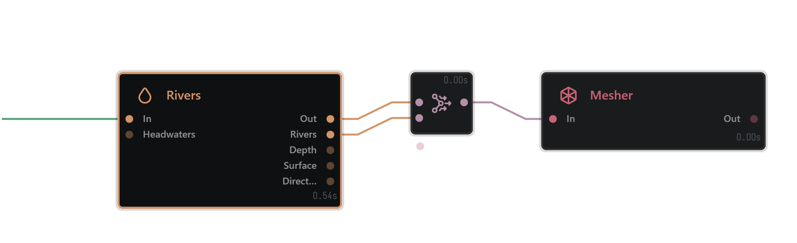
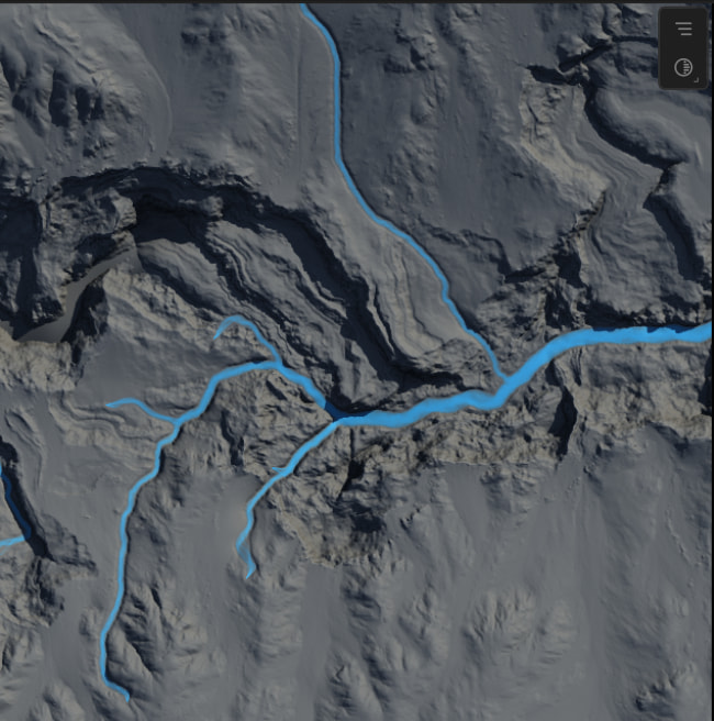
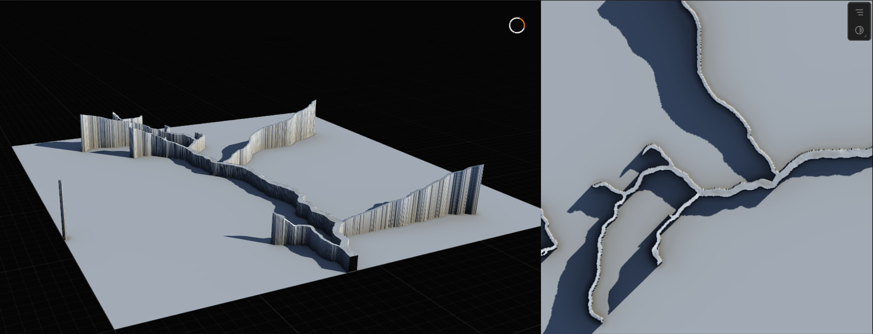
I’ve had a glance over the documentation and videos. Unfortunately, seeing a lot of Gaea 1 tutorials (easily makes a river surface mesh) but I can’t figure out how to replicate in Gaea 2.

I believe I am getting the hang of creating masks for UE 5.7. Still not sure if I’m exporting the right ones but they’re black and white and make sense/tested to drive auto material.

I would like to create a map that is considerably larger than 5km². I am understanding of computer limitations. I don’t intend to create a 256km² map and slap nanite over it. Please let me know if 32km²
is doable or ambitious. I have good PC specs but I also want the average person playing this eventual game to have an enjoyable experience. How does 48km² compare or does the processing/rendering power increase exponentially? (Thinking of this example: 1009 = Just over 1m points of height detail versus 4033 16m points).

Can someone please explain what resolution actually means? Does the meaning change at any time? Someone said UE considers “resolution” as meters and I have been confused ever since.
A 2048 resolution texture will have significantly more detail than a 1024 texture. I see the difference in Gaea. Because I am working with UE, I want the 1009, 2017, 4033 resolutions, right? Does the resolution here just concern the geometry
of the peaks (and rock detail)? My argument is the auto material (scattered PCG in the material versus the landscape itself) will be contributing to the detail as opposed to the landscape driving the detail or am I wrong?
Auto material parameters like planner projection, cell bombing, etc make this a non-issue. Cell-bombing has its own problems, but I was just giving an example. Any recommended landscape resolution and why?
The focus is gameplay, not cinematics. 2017 is a consideration should it matter.

If I upload a 1009 texture and play with the X,Y scale to get a large map/48km², I will be stretching it. Something like 32m per vert. No good.

I apply a width of 6930m (48km²) to the terrain definition, and this appears as “realistic” in both Gaea 2 and UE but looks boring. So then, I normalize the export in Gaea 2 and get a nice map but as a solid chunk. No good.

So, to build a large map, it is my understanding I will need world partitioning AND tiling. But, evidently, not by normalizing the export. Sigh.

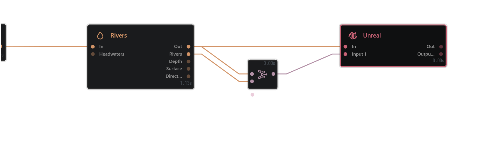
Tried two methods to importing from Gaea 2 to UE. The manual method using the Unreal node and the plugin.

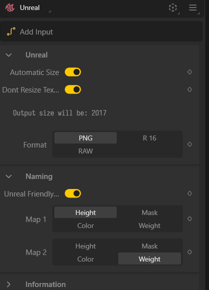
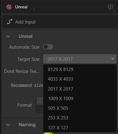
I didn’t see that I have an option to use Unreal’s 1009, 2017, etc resolutions so I select I want 2048 resolution with 1024 tile and it spits out four y0_x0, etc textures.
Error uploading so I rename to only include the “y0_x0”. Works. Notice a so-called “border issue”, stretching along the edges. Is this because I’m using a 2048 texture as opposed to a 2017 texture?

I’ve noticed some differences between exporting manually and plugin. With the plugin, I only have the option to set “World Partition Grid Size”. Are the 4 tiles assumed to be the “World Partition Region Size”? Importing 4, 1024, y0_x0, y0_x1, y1_x0 and y1_x1…
Now I only see one giant y0_x0 landscape. Noting UE only allows me to choose one tile so I choose y0_x0 and it “detects” the rest. Other times, (assuming 1 tile is 1 region), I specify 4 regions and I see y0_x0 4 times.

Having trouble understanding UE partitioning as is but I’m not sure if anyone here would be able to help with that.

Thanks for reading and your help.

River meshes are fairly straightforward
rivers out and rivers - river into a combine - multiply - 100
This will leave you with just the rivers, then adding a mesher at the end you’re ready to build and export.

By the looks of your next sentence however you want a Mask to drive materials rather than a mesh.

By that logic you’ll want to set up the /unreal node with the heightfield output, then the river mask set to mask on the node properties.

Yes Gaea 1/2 can easily create a 32km² map ( default is 25km²)

It is doable, but it is ambitious depending on your end goals, 1m or 2m per px resolution target is the go to defacto for open world games like this, this may seem low res but you must balance memory limits ( even with streaming tools) with RAM and VRAM you can see res targets in build options under the Terrain Definition

id start here before goign into tile or region builds ( higher gaea licenses.

it typically means two things here
1 image/data resoution
2 Spatial resolution ( how much physical space per px covers)
you probably mean the second in this case which is the density of world space.
A terrain heightmap is just a grid of height samples.

So if you have:

a 2049 × 2049 heightmap
covering 2048 meters across

then you effectively have about 1 meter per sample.

If that same 2049 × 2049 map covers 4096 meters, then it becomes about 2 meters per sample.

If it covers 1024 meters, then it becomes about 0.5 meters per sample.

So: same pixel resolution, different world size = different practical terrain detail density

UE explains this a little cross diciplines but essentially
resoltuion of the map, how big that map is across a landscape, the physcial scal eof the landscape.

Gaea is purely looking at making the data so it’s just resoltuion, but the terrain definiiton helps people decide if the numbers match their renderer goals so they know that the data would create before appling the renderer requirements.

You dont _have_ to build a tile build in Gaea you can still just use the /unreal node. this fits well with what i mentioned earlier with 1m or 2m per px this is a 4k or 8k build in gaea ( which you can do as a single tile)
the Gaea2Unreal tool can set this up for you, finally you would use world partition to manage your streaming ( an importantly the memory cost)

This is automatic by default in gaea base resolution selction in the build menu, for example the unreal node will select 2017 if you make a 2048 build in gaea.
you can manually select this in the node properties if you set automatic - off

Im not super familliar with PCG but if it running off the resoluution of a data layer, then you data layer can be completely differet resolution to your heightfield if you want it to be, i am presuming that your data is either landscape verticies or texture data samples ( or point cloud)

Hope this helps steer you in the right direction.

1 Like

Thank you so much TyXanders, looking forward to going over your recommendations with a fine tooth comb.

1 Like

I should mention I have access to tiled builds in Gaea 2 Indie. As mentioned I’m not trying to do extreme environments, just ones I consider big enough (reason being I’m reading I keep the resolution per tile w/o stretching it - maybe this is where the confusion is coming from).

It was my understanding for a larger map (I will define this with an arbitrary limit of 48km2), before being considered extreme environments (256km2 - and a Gaea upgrade is necessary here I see - edited for clarity) tiles are necessary. How do we know which resolution we’re after?

So a 4033 resolution covers both quality and distance? 4x4 (4033) = 16km2? So is this where the determining factor is when selecting the resolution (quality)?

So if I wanted 64km2 I’d want to output an 8k heightmap? If I use a 2k map to cover 64km2 I’m stretching the pixel density, am I getting this right?

I’ve achieved this generic look through experimentation (see attached image). As you can see, rivers are flat when masked.

This is where I find Unreal confuses it a smidge

There are of course times where 4033 resolution can match 4033 XY scale for example, but it’s not a gold rule.

In the tech docs it gives you recommended height field resolutions as well as the configs for the landscape.

Recommended landscape scale

None of those are scale this is just the component config.

Your scale is essentially what you you’re setting up yourself in. You’re only building the resolution in Gaea and unreal is only building the components at the components config. The XY scale is the only part where you determine the actual size of the final landscape.

What matters is the relationship between scale and resolution is what you intend it to be ( like where I mention 1m/px) this is the “stretch” that you’re mentioning

For example 5000x5000 m landscape from an 8129×8129 heightmap, the spacing is:
5000 / 8128 ≈ 0.615 m per sample ( higher density/quality/more resources req. than 1m/px)

That means the terrain is still 5 km across physically either way; the higher resolution just means the terrain is sampled more densely visually

Thanks for your continued support, I think am finally understanding this now.

Playing with Terrain Definition I can see what happens when I change the image resolution and play with the width scale. I can see how now, to choose my desired square km and which resolution I will require to get that desired 1-2m/px to mitigate stretching (but not eliminate it as I will demonstrate below).

For example, if I wanted a 4x4k map, I’d use a 4k texture. 16x16k I’d use an 8k texture. So the tiling workflow effectively begins if I want something greater than this threshold as a 17x17k map and respective texture size is uncommon/unsupported.

In Terrain Definition, the “width” is what gives my XY is my understanding. Where the problem is: The “height” in the Terrain Definition is also contributing to the m/px.

So if change terrain definition width to 5660, I have a 32km2 map.. but.. a 5660x5660 texture doesn’t exist.

So > Outputting a 5660 XY using a 4k texture = some stretching.

Do I use tiles to build it? How does the height contribute here? The default height is 2500. As mentioned, looking very flat and boring but I reckon I’m still getting 2500m height on that terrain. If I wanted something more visually appealing, I’d bump up the height. But… to what?

5660 XY and 5660 height Z? 1.382 m/px.

OR am I halving it as the default demonstrates? 5660 XY and 2780 Z? 1.382 m/px.

Finally (and I really appreciate your patience here), 5660 XY and 5660/2780 Z with an 8192 I get .691 m/px.

Think I answered my own question about the tiles lol.

No trouble at all.

I have an article Manually Importing into Unreal

Which may help you further bridge some questions here for you if you’re still having a few issues.

I think we may mark this as resolved. Here in Blender I’m experimenting with the overlay. What was confusing was I wasn’t getting accurate results until I realized I exported my height map as the terrain mesh. Instead, it’s height map + rivers (no particular attention to downcutting)> as one mesh and rivers + lake > combine node as the other mesh. I see the depth (but not for the lake). Might just be that I have to separate these. Not sure how I feel about the rivers running to -256 though. Am I supposed to be applying boolean or any modifiers to clean this up or is this it? In the second example I manually play with difference and get a depth I like.

Seems I forgot to blur. What’s left is figuring out whether this mesh goes into UE or this “.EXR”. Nonetheless, exciting stuff!

1 Like